2710 S 1070 W - the Jordan River's East Banks
August 23, 1846
DonnerReed Party camped on the banks of the Jordan River
Here is a bit from James Reed's journal............
James Reed
James Reed, born in Ireland caught The California Gold Fever in 1846.
He and his wife Margaret decided they would take the family from Illinois to California. James built his wife a 2-story wagon with stove, spring seats, bunks for beds and stocked it with fine food and liquors.
It was hard for the family to leave friends, daughter Virginia wrote “ My father, with tears in his eyes, tried to smile as one friend after another grasped his hand in a last farewell. Mama was overcome with grief."
The journey to California was 2500 mile. They anticipated arriving August 1846.
Margaret had been suffering from terrible headaches for years and there was hope that the California weather would help her feel better. Margarets mother was also a very ill woman but she insisted on going with her daughter and the 4 Reed children.
By June they were already about a week behind schedule.
In Fort Laramie they were told about a new trail called “the Hastings Cut-off” that should cut about 400 miles from there trip to California. It took them south around the Great Salt Lake.
The Reed family and many others joined George Donner's group and many other families that chose to travel through the Hastings Cut-off elected.
George Donner as wagon train captain. Many told the group that the path was a good choice, even Mountain man Jim Bridger told the Donner Party that the Hastings Cut-off was a good route for them.
July 31,1846
74 people in 20 wagons traveled 10-12 miles per day.
On August 11th
they approached the Wasatch Mountains, where there were thick trees, large rocks and other things that made wagon travel almost impossible.
On August 22
they crawled down Immigration Canyon. The 36 mile journey that they just traveled should have taken 4 days but had taken 17 days.
August 23-The Jordan River
James Reed and the lead wagon went ahead to scout out the safest route. He writes:
August 23,1946: “ Left camp late this day on account of having to find a good road or pass through the Swamps of the Utah Outlet. Finally succeeded and encamped on the East Bank of Utah Outlet. Making 5 Miles” - James Reed
On August 30, Great Salt Lake Salt Flat Desert, was also hard for wagons to maneuver. The Salt/Sand made them abandon many wagons in the desert. 32 oxen and many cattle died at that point. They were now way behind on their journey.
For decades the Donner-Reed wagon trail was visible along with many of the wagons that were abandoned due to the Salt/Sand that made it nearly impossible
Most of us know the rest of this heart-wrenching story that happened just 3 months later in the mountains of the Sierra Nevada's. James Reed had been banished from the group and he was trying to get supplies for them, he suffered greatly. His wife and children were stuck the full winter and suffered from starvation. Mrs. Reed spent 2 weeks walking through snow over 20 feet deep to try to find food and help for the Reed children. The party was finally rescued and the Reeds resided in California and had many business successes.
The Original Marker
This is a picture of the original marker that disappeared.
When I noticed the marker was gone, I called Bill Evans and he scoured the banks of the river and trail for the marker. He couldn't find it either so we called The Utah Crossroads team. They immediately went to work to call many different agencies to gain permission to place a new marker on the site. It took many months for the Utah Crossroads Team to purchase and create a new marker and get permission to place another marker on the site.
Original Marker
The land is owned by the neighboring Radius Engineering, who graciously allowed the marker to be placed on their land.
Driving to the Monument
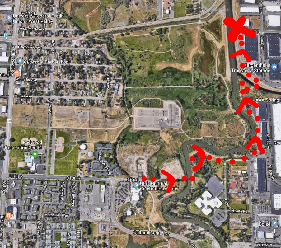
Take 900 west from either 3300 South or 2100 South. Turn on 2780 South and head to the Jordan River. Park your car and walk to the Jordan River. The monument is right at 2780 S
WALK along the Trail
If you want to take a 20 minute walk, or 5 minute bicycle ride to the monument follow these directions:
Park at the Utah Cultural Celebration center and take the Historic Suspension Bridge to the EAST side of the Jordan River and follow the trail until you reach the monument at 2700 south
It was an enjoyable walk for me and my boys from the UCCC building, over the suspension bridge and through the Jordan River asphalt trail to the monument marker
The Utah Crossroad Team:
Jesse Petersen along with his son made the monument marker from an old historic train track rail.
Victor Heath
Bryce Billings
Terry Welch ( Local Chapter President)
Drew Wanosik (Treasurer)
Marie Wanasik
Nancy Petersen
The marker is right next to this drinking fountain that is supplied by Radius Engineering. The same company that gave permission for the marker to be placed on their property.
More Information about these markers
The Crossroad Chapter has published a booklet of all the markers they have installed. The booklet gives the GPS coordinates for each marker.
You can purchase the booklet for $10. To order please email : dwanosik@xmission.com
This is an amazing group of volunteers that give of their time, talents and money to help preserve history. They have a wonderful website: https://www.utahcrossroadsocta.org/


